Hi all,
I'm in the midst of doing a fairly labour intensive process of converting pdf vector images into shapefiles using inkscape to isolate the layers that will be digitized. I am having issues with assigning the colours at the end, as the process I am using introduces alot of noise in the vector to raster conversion step.
Basically, the process I am using is as follows
1. Use inkscape to isolate the vector layer in the pdf that needs to be digitized. These are polygons filled with a specific colour which will need to be attributed back to the final polygons.
2. As ArcGIS has limited ability to read vector graphics, i have to convert the drawing to a high resolution (as high as i can go without blowing up my machine) raster format (i've been using .tiff and .jpg) to bring it into ArcGIS (attached).
3. ArcGIS has a useful feature called ArcScan which automatically vectorises rasters. At the end of this, i have a replica of the original pdf as a shapefile vector (without any attributes or associated colour data)
4. Use ArcGIS to figure out where the centre of the digitized polygon is, and to assign a RGB value of the original polygon from the raster to the final vector shapefile.
Step 4 is where the problem arises. Because of noise issues, polygons that have the same RGB value in the original all have small RGB value variations in the final product. As alot of the original colours are very close, its very hard to figure out where one colour becomes another...
Question: Is there a raster format or method i can use to minimize noise in the vector - raster conversion process in inkscape?
Inkscape and ArcGIS automatic vectorisation
Inkscape and ArcGIS automatic vectorisation
- Attachments
-
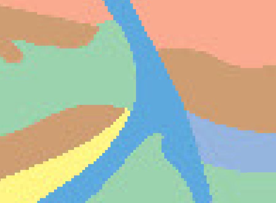
- The noise I am dealing with...
- noise digitization.JPG (39.77 KiB) Viewed 4706 times
Re: Inkscape and ArcGIS automatic vectorisation
Hi there!
Have you tried the save as dxf option in inkscape?
Arcgis can import dxf files, so maybe it's totally unnecesary to rasterize the image before it will be turned again back to vectors.
OK I don't really get the basic workflow of yours.
If you even exported vectors to png in inkscape they won't get jpeg compressed as the rasters in the pdf-s.
You have vector elements in your original pdf-s, or all the wanted parts are rasters?
If you don't have the original rasters that are embedded into the pdf-s, you cannot be 100% sure with colours,
as they are lossly compressed by default in pdf-s.
Try to avoid jpeg format, if you save some exported png-s to other raster format.
Re: Inkscape and ArcGIS automatic vectorisation
Lazur URH wrote:Hi there!
OK I don't really get the basic workflow of yours.
Same.
-
thegitksan
- Posts: 3
- Joined: Sun Aug 11, 2013 11:47 am
Re: Inkscape and ArcGIS automatic vectorisation
Hi! I occasionally have to deal with getting data from a vector PDF into a shapefile as well. Have you have any luck with your explorations yet? I've done it twice myself, with fair results, but it's been a while. Used Inkscape to separate polygons into layers, then export them I think to DXF (will have to check), and then import to ArcGIS.
Interested in the ArcGIS-Inkscape cross-over, as I am thinking of trying to do a high-end map in imitation of the very expensive Illustrator mapping module.
Have you had any luck?
Interested in the ArcGIS-Inkscape cross-over, as I am thinking of trying to do a high-end map in imitation of the very expensive Illustrator mapping module.
Have you had any luck?